Mapped Community Complexes
Learn More
Other Websites
Why don’t all communities show up on the map?
If you look at the interactive map of Harpers Ferry National Historical Park (NHP), you might be puzzled that you can’t find some natural communities—say the Rocky Bar and Shore – Water-willow Type. That’s because some communities are mapped together in groups or complexes under another name. Usually these communities occur in patches too small to map, or they tend to be found together in mosaic fashion. Sometimes, in dynamic environments such as shorelines, the communities move often enough to make detailed mapping difficult.
In Harpers Ferry NHP, there are three such groups of natural communities that are mapped together as complexes.
Explore these three community complexes:
- Herbaceous Depositional Bar Complex
- Riverscour Woodland Complex
- Riverside Rock Outcrop and Prairie Complex
Herbaceous Depositional Bar Complex
The natural communities in the Herbaceous Depositional Bar Complex grow on unstable sandy or rocky bars and banks along the shores of the Potomac and Shenandoah rivers. Frequent flooding rearranges the sediment that supports the plants, so the location of these communities can shift regularly. Floods wash away small shrubs and trees before they can mature.
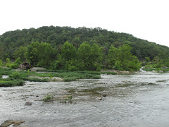 River Scour Woodland and Herbaceous Depositional Bar Complexes at Harpers Ferry NHP.
Photographer: Tom Govus, courtesy of NatureServe.
At Harpers Ferry NHP, these natural communities are mapped as a group in the Herbaceous Depositional Bar Complex, and together cover 12.6 acres (5.2 hectares):
Orange Jewelweed Herbaceous Vegetation
Riverbar Drawdown Shore
Riverbar Tall Wet Meadow
Rocky Bar and Shore – Water-willow Type
Scour Bar Wet Meadow
Map tip: To see where this occurs, go to the interactive map of Harpers Ferry NHP and search for "complex." Look for Herbaceous Depositional Bar Complex under Natural Communities (All Locations) results.
Riverscour Woodland Complex
The natural communities in the Riverscour Woodland Complex grow on bedrock shelves or rocky bars in and along sections of the Potomac and Shenandoah rivers that are steep and fast-moving. Flood-damaged trees—sometimes stunted and widely spaced—grow in these frequently flooded natural communities.
At Harpers Ferry NHP, these natural communities are mapped as a group in the Riverscour Woodland Complex, and together cover 34.1 acres (13.8 hectares):
Bedrock Floodplain Forest
Sycamore - River Birch Floodplain Forest
Map tip: To see where this occurs, go to the interactive map of Harpers Ferry NHP and search for "complex." Look for Riverscour Woodland Complex under Natural Communities (All Locations) results.
Riverside Rock Outcrop and Prairie Complex
The Riverside Rock Outcrop and Prairie Complex is found on slabs of bedrock that jut out of steep sections of the river, where floods (or ice) periodically scour the surface. Grasses and wildflowers grow out of cracks in the rock.
At Harpers Ferry NHP, this complex consists predominantly of the Riverwash Bedrock Prairie natural community, and covers 6.6 acres (2.6 hectares).
Map tip: To see where this occurs, go to the interactive map of Harpers Ferry NHP and search for "complex." Look for Riverside Rock Outcrop and Prairie Complex under Natural Communities (All Locations) results.