Faults are fractures in the earth where the bodies of rock on either side of the fracture have moved relative to one another. Rock Creek Park hosts one of the major fault zones in the Mid-Atlantic Piedmont. Known as the “Rock Creek shear zone”,1 this complex of faults runs straight up Rock Creek Park, passing beneath such major landmarks as Thompson Boat Center, the National Zoo, Peirce Mill, and Boundary Bridge. The fault zone is thought to have been active for at least 460 million years, and geologists have documented several periods of motion, including an episode of relatively "recent" (by geologic standards) fault motion that is well-displayed near the National Zoo and has affected the course of Rock Creek. The rocks on either side of the fault zone may be offset by as much as ten miles!
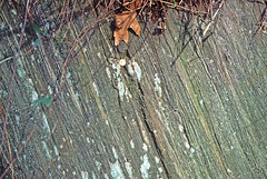 Mylonite (stretched bedrock), formed from the Laurel Formation, Porter Street, D.C.
Photographer: Tony FlemingRepeated motion on the fault zone (or “shear zone”) has produced a half-mile-wide band of severely flattened, cleaved, and stretched rock known as mylonite. Mylonite can be made from any kind of rock that is subjected to this kind of pressure. Its significance to understanding natural communities at Rock Creek Park is that it marks the boundaries between different blocks of bedrock. Look for the lustrous, layered rocks throughout the lower, eastern parts of Melvin Hazen, Soapstone, and Broad Branch Valleys, on the bluffs below Klingle Mansion, and along Rock Creek between the National Zoo and Broad Branch.
(Tip: Locate two examples of mylonite outcrops by typing "mylonite" into the Search tool (upper left corner) on the Rock Creek Park Map Viewer.)
- 1. . 1998. Structure, age, and tectonic setting of a multiply reactivated shear zone in the Piedmont in Washington, D.C., and vicinity. Southeastern Geology . 37(3):115-140