Stream and Riparian Ecological System
| Open Park Map |
Learn More
The Stream and Riparian Ecological System in Rock Creek Park can be easily recognized by its position along streams. The low-lying areas it occupies are subject to temporary flooding or nearly constant saturation from groundwater.
Natural Communities in This Ecological System
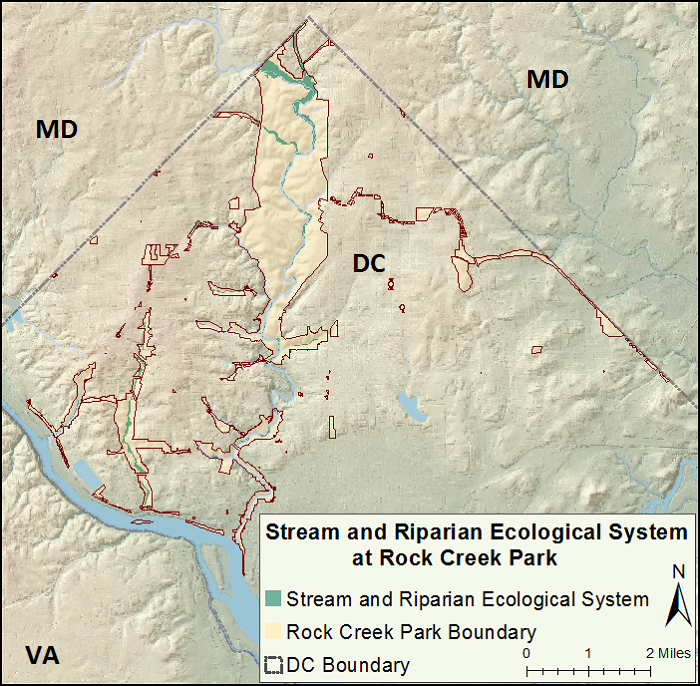
Stream and Riparian Ecological System in Rock Creek Park
- wetland system in low-lying areas along streams and tributaries
- subject to flooding and erosion, or to groundwater saturation
- wetland trees and tuliptree in the canopy
- abundant spring wildflowers
Natural Community: Tuliptree Small-Stream Floodplain Forest
- on floodplains and banks of Rock Creek and other tributaries
- banks are sandy and stony, but the soils on the floodplains beyond them are fine-textured and nutrient-rich
- sycamore, river birch, wood-nettles
Natural Community: Red Maple Seepage Swamp
- in groundwater-fed depressions at the base of hills and along floodplains
- skunk-cabbage is striking in spring and early summer, but is hard to find at other times
- generally lacking sycamore and river birch
Plants in the natural communities of this ecological system must tolerate at least temporarily saturated soils. Soils are rich with plant nutrients.
At Rock Creek Park and throughout its range, the Stream and Riparian Ecological System typically is found along the narrow floodplains of small to medium-sized creeks or their tributaries.
Tip: to see ecological systems on the interactive map of Rock Creek Park, use Layers On/Off to switch the main data layer to Ecological Systems.
Images of This Ecological System
Physical Setting
The Stream and Riparian Ecological System tends to be narrow because it develops on floodplains of small streams winding through mountainous or hilly terrain. By contrast, streams and rivers that flow through the sandy Coastal Plain would have broader floodplains because the land there is more level and more easily eroded.
Tucked among the hills such as those of northwestern Washington, D.C., this ecological system is located along the valley floor of Rock Creek and its tributaries, and it is quite narrow for the most part. It is at its widest along Rock Creek where it enters the District of Columbia from Maryland.
Where to See It in Rock Creek Park
Natural Processes That Maintain This System
Natural processes are responsible for maintaining the character of an ecological system.
Flooding and Erosion
Due to its location, the Stream and Riparian Ecological System is heavily influenced by flooding and erosion. Forests living on the floodplain are subject to flooding, but the frequency varies. Forests very near the stream banks may flood several times a year, while those farther away may flood only once every 100 years.
Groundwater Processes
Some sites in this ecological system are saturated or even submerged by groundwater. Especially in late fall, groundwater can pool in low-lying and poorly drained areas. In summer, tree roots suck up water and leaves give off water vapor, essentially pumping water from the soil into the atmosphere. After autumn leaf-fall, trees suspend their water-pumping function, and groundwater may pool on the surface.
Floodplains are places where water can travel from groundwater to surface water or vice versa. When floodplain soils are not saturated, water can percolate down through them to help replenish the water table—a process known as groundwater recharge. On the other hand, in the process known as groundwater discharge, groundwater from higher elevations can also make its way slowly down through pores in underground rock until it reaches the floodplain, where it may come to the surface as a spring or simply pool on the surface as it does in the Red Maple Seepage Swamp, where it typically keeps the ground saturated for most of the year.
Ecological Threats to This System
Stormwater Runoff
In urban and suburban areas, the Stream and Riparian Ecological System can be damaged by increased stormwater runoff caused when rainwater quickly runs off roads and parking lots into storm drains—straight to the nearest stream. The sudden influx of large amounts of water causes erosion of stream banks. The increased erosion can expose the roots of streamside trees, eventually causing them to tumble into the stream. Stormwater runoff also brings with it pollution from roads and parking lots—including litter, car fluids, and herbicides and pesticides used on lawns.
While more stormwater is rushing directly into nearby streams, less water is soaking into the surface. This can lead to a decrease in the amount of groundwater, and a lowering of the water table, which negatively affects ecological systems like the Stream and Riparian that depend on groundwater processes. Read more about water issues in Rock Creek Park's urban setting.
Non-Native Invasive Plants
Non-native invasive plants are one of the greatest threats to the Stream and Riparian Ecological System. The soils are fertile and frequently disturbed by flooding, allowing new seeds and plants to take root. Flooding removes leaf litter and exposes the soil to sunlight, and also brings in seeds and plant parts from upstream. Bird and animals coming to the stream for food or water also spread seeds in their droppings and on their feet, feathers, and coats. Some of the most common non-native invasive plants in the Stream and Riparian Ecological System at Rock Creek Park include:
- bush honeysuckle* (shrub)
- English ivy* (vine)
- garlic mustard* (low plant)
- Japanese honeysuckle* (vine)
- Japanese hops* (shrub)
- Japanese knotweed* (shrub)
- Japanese snowball* (shrub)
- Japanese stiltgrass* (low plant)
- lesser celandine* (low plant)
- multiflora rose* (shrub)
- oriental bittersweet* (vine)
- porcelain-berry* (vine)
- silktree* (tree)
- winged burning-bush* (shrub)
Over-Browsing by Deer
White-tailed deer—seriously overpopulated in the park—heavily browse the plants in the Stream and Riparian Ecological System. Their high population is a region-wide challenge affecting the future of all forest ecological systems. Read more about the population dynamics of white-tailed deer in Rock Creek Park.
Other Threats
Several non-native diseases and insects pose threats to native plants of this system. Green ash and pumpkin ash trees are seriously threatened by the emerald ash borer. American elm and slippery elm could succumb to Dutch elm disease or elm yellows. The viburnum leaf beetle threatens southern arrow-wood and blackhaw. Gypsy moth and sudden oak death are potential threats to oaks. The Asian long-horned beetle would damage maples, box-elder, elms, river birch, American sycamore, and willow.
Range Beyond Rock Creek Park
Occurring over a wide range of elevations from southern New England west to Lake Erie and south to Virginia and West Virginia, the Stream and Riparian Ecological System is at the eastern edge of its range at Rock Creek Park where it extends slightly into the Coastal Plain. The James River in Virginia marks its southern extent. The official name of this ecological system, Central Appalachian Stream and Riparian, reflects the extent of its range.